TRAIL OF THE CUEVA DE LOS MUÑECOS
Description
The culture of the Iberians keeps many mysteries that may never be explained. Their beliefs are almost unknown, but no one is surprised that they had in these places one of their main places of worship, and even more so that the Romans would take on him to satisfy their gods.
Datos de la ruta
ROUTE NAME
Sendero de la Cueva de los Muñecos
TRAIL TYPE
Linear
DIFFICULTY
Media
TOTAL DISTANCE (IN KILOMETERS) 3,2 km
-
Stretch of asphalt or concrete:
-
Section of track, forest road, or dry watercourse:
-
Trail section:
-
Sections of livestock trails:
HUSO 30S
ESTIMATED TRAVEL TIME
1 h 42 min
ROAD SURFACE TYPE
Trail
ELEVATION CHANGE
150mm
150mm
DIFFICULTY. RATING ACCORDING TO THE MIDE METHOD
2
MEANS
Severity of the natural environment
2
ITINERARY
Route guidance
2
DISPLACEMENT
Difficulty moving about
1
EFFORT
Amount of effort required
ACCESSIBILITY TYPE
On foot
TIME OF YEAR
All year round
SIGNALING
No
MORE INFORMATION
TUNNELS
STEEL VIADUCTS
METAL WALKWAYS
WATER POINTS
PONTOONS
GUARD BOOTHS AND BARRIERS
SWITCHMAN'S CABINS
CYCLABILITY
RECREATIONAL OR SPORTS AREAS NEAR THE TRAIL
AID STATIONS
LINKS TO OTHER TRAILS
SHELTERS
RECOMMENDATIONS
It is recommended to wear safe drinking water and clothing and adequate footwear. Ensure the potability of the water from the sources. This path can be realized throughout the year. In summer, due to the special conditions of height, the insolation is very strong and requires important solar protection. Caution with the strong slopes of the last stretch and the pozas of archaeological excavations.
OTHER INFORMATION OF INTEREST (ARCHITECTURAL OR HISTORICAL-CULTURAL, GEOLOGICAL-ECOLOGICAL)
- Centre for the Interpretation of the Historical and Cultural Heritage of the Natural Park of Despeñacolos
- Cueva de los Muñecos, which dates back to the 6th century BC and is considered one of the oldest Iberian extra-urban shrines, and also of those who had a certain character of territorial control.
- Cerro del Castillo, at 961 m altitude, old Iberian settlement.
- The organs.
Technical Description
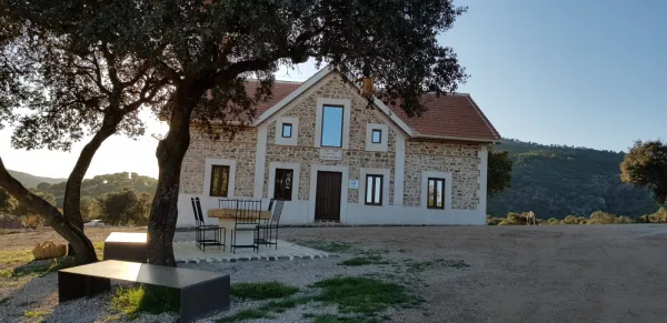
The path begins at the Centre for the Interpretation of the Historical and Cultural Heritage of the Natural Park of Despeñacolos (see on the map), which is reached by the road A-6,200 from the E-05 motorway, towards Aldeaquemada. The center has been built on an old aprisco at the foot of the hill of the Castle. On the contrary side of this run through the historic passage of Despeñapeas the highway of the South.
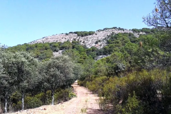
However, on this side where we find the intense traffic of the fast track seems far away. The visit to the centre is certainly recommended, as it provides information on the natural and cultural heritage of the environment and also of this path. Around the center we see places of great ecological significance. On the umbria slopes, facing north, we will see forest formations with tree leaves, like the whine, and shrubs like doves or madroños. On the other hand, in the solana, the mountain is dominated by cobblestones with little sodoscala, made up of pyruetans, jars, rosemary, etc.
The path consists of two sections of about five hundred meters each, starting both from the interpretation center. One goes up to the hill of the Castle - towards the west - and the other goes down to the cave of Los Muñecos, in a southwestern direction. Although the order to travel them is indifferent, as in any case we must return to the interpretation center, we will assume that we will first take the climb to the hill. The sinuous path that we will take goes through a relatively lush encore that disappears around the 920 meters. Then, until the top of the hill, at 961 m, we will see more naked rock than vegetation.
There are in the high remains of a possible Iberian village and a lookout towards the plateau with overwhelming views, with St. Helena to the south and the port of the Muradal to the Plateau. In front, the impressive pettic structure of Mount Los Organos and, under us, the highway that follows the itinerary that with great difficulty opened at the end of the 18th century, as an alternative to the road of Las Ventes (by Los Pedroches) and other itineraries in use between the ports of Cadiz and Sevilla - doors of Américo - and the capital of the kingdom.
After walking the way to the center of interpretation, we will head towards our second destination, the cave of Los Muñecos. We will descend on a soft slope by the skirt of the hill of the Castle, and in parallel to the electric slope, towards the road we arrived for, we will cross the lower part of the same oak that we have already met up to the hill, in which we will also see alcornoques and junips of great bearing.
In two hundred and fifty meters we will reach a point very close to the road, where we will change course to surround the cut we see on our right, in which environment we can distinguish maples of Montpellier and abundant cornicabra. We must be careful with some slopes and pozas of the numerous excavations around here, as we are in a rich area of archaeological deposits, with the cave of Los Muñecos as the center of them, where the path ends.