Source of Tercero
Description
To get to the place of departure of the excursion you have to take, at the exit of Fries, the asphalt lane that leads to the cortijos of Los Rosales and Cerezo Gordo. After leaving to the right the zigzagueante lane of Noalejo, reach the Portillo Pinatero and from there descends directly to the Cortijo de La Fresnedilla where the car is left.
Datos de la ruta
ROUTE NAME
Nacimiento del Tercero
TRAIL TYPE
--
DIFFICULTY
--
TOTAL DISTANCE (IN KILOMETERS) --
-
Stretch of asphalt or concrete: --
-
Section of track, forest road, or dry watercourse: --
-
Trail section: --
-
Sections of livestock trails: --
HUSO 30S
ESTIMATED TRAVEL TIME
ROAD SURFACE TYPE
Trail
--
--
DIFFICULTY. RATING ACCORDING TO THE MIDE METHOD
--
MEANS
Severity of the natural environment
--
ITINERARY
Route guidance
--
DISPLACEMENT
Difficulty moving about
--
EFFORT
Amount of effort required
ACCESSIBILITY TYPE
TIME OF YEAR
SIGNALING
No
MORE INFORMATION
TUNNELS
STEEL VIADUCTS
METAL WALKWAYS
WATER POINTS
PONTOONS
GUARD BOOTHS AND BARRIERS
SWITCHMAN'S CABINS
CYCLABILITY
RECREATIONAL OR SPORTS AREAS NEAR THE TRAIL
AID STATIONS
LINKS TO OTHER TRAILS
SHELTERS
RECOMMENDATIONS
OTHER INFORMATION OF INTEREST (ARCHITECTURAL OR HISTORICAL-CULTURAL, GEOLOGICAL-ECOLOGICAL)
Technical Description
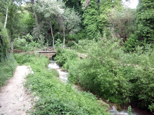
Not far from the road and just in front of the cortijo, it starts on the right a signposted path parallel to the stream, which later must be watered shortly before the wire. Once on the other side, the explanade is crossed in search of a path that penetrates the beautiful throat of the Arroyo de la Fresnedilla.
The ravine gradually narrows and forces several times to change the shore. At the confluence with another stream and after walking about 25 minutes, the ravine opens. At this point you have to move to the right margin to link with a dirt lane. The road now accompanies the rising river bed, on some occasions on the right bank and on others, on the opposite. Unavoidably, you have to go through the channel several times, and if it has a lot of water, you will even have to go down on more than one occasion.
Finally, the lane disappears. The route continues to jump from one bank to another in search of the most comfortable steps to a dam and waterfall, after an hour and ten minutes.
It is taken on the right bank, the sidewalk of the acequia that used to carry the water from the chorreta to the old light factory, in the Barranco de Valdearazo. Place where the route ends.