ALTERNATIVE GR 247.1 STAGE 1: Prado Maguillo and Forestrand House Refuge El Bodegón - Río Madera
Hiking, GR247 Forest Routes
Santiago Pontones



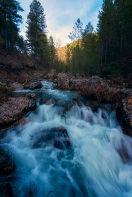
This hiking route is, of course, the most popular route in the Natural Park, which also implies the possibility of a certain massification at a short time. The set formed by the fast waters of the Borosa, the rocks in which the channel is fit and the closed riverside vegetation, is one of the most spectacular river scenarios in southern Spain.
Is part of

ROUTE NAME
RÍO BOROSA A SALTO DE LOS ÓRGANOS
TRAIL TYPE
Short-distance trail. Linear
DIFFICULTY
Media
TOTAL DISTANCE (IN KILOMETERS) 8,92 km
Stretch of asphalt or concrete: 0
Section of track, forest road, or dry watercourse: 71.75%
Trail section: 28.28%
Sections of livestock trails: 0
HUSO 30S
ESTIMATED TRAVEL TIME
2 h 10 min
ROAD SURFACE TYPE
Sandy and rocky
ELEVATION CHANGE
619mm
143mm
DIFFICULTY. RATING ACCORDING TO THE MIDE METHOD
3
MEANS
Severity of the natural environment
1
ITINERARY
Route guidance
2
DISPLACEMENT
Difficulty moving about
2
EFFORT
Amount of effort required
ACCESSIBILITY TYPE
TIME OF YEAR
SIGNALING
No
PERFIL DE ALTURAS

MORE INFORMATION
TUNNELS
STEEL VIADUCTS
METAL WALKWAYS
WATER POINTS
PONTOONS
GUARD BOOTHS AND BARRIERS
SWITCHMAN'S CABINS
CYCLABILITY
RECREATIONAL OR SPORTS AREAS NEAR THE TRAIL
Badén and Los Rodeos Bridge
AID STATIONS
LINKS TO OTHER TRAILS
SHELTERS
RECOMMENDATIONS
In its initial route that coincides with the GR 7 that separates from our route on the Bridge of the Snails, the path can be continued towards the Embalse of Aguas Negras and Laguna de Valdeazores crossing the tunnels, from the Jump of the Organs.
OTHER INFORMATION OF INTEREST (ARCHITECTURAL OR HISTORICAL-CULTURAL, GEOLOGICAL-ECOLOGICAL)
Technical Description
This hiking route is, of course, the most popular route in the Natural Park, which also implies the possibility of a certain massification at a short time. The set formed by the fast waters of the Borosa, the rocks in which the channel is fit and the closed riverside vegetation, is one of the most spectacular river scenarios in southern Spain.
To start the route we go to the Visitors' Reception Centre of the Torre del Vinagre, in the Carrier A-319, and we take a detour to the River Borosa River River River River River River. The path begins right from the farm next door.
At first, the tour goes through a closed forest track to the traffic of private vehicles that always goes parallel to the river's path, being one of the most pleasant walks that can be made in the Natural Park, especially in its initial section.
At first it coincides with the route of GR 7, up to the bridge of the Snails where we leave this Grand Tour, to continue parallel to the Borosa River. In the km 3.3 we left the track on which we went to the left to continue by the river, along the path and through the Cerrada de Elias, a rocky cling of the channel, full of clear and cold waters. Later on we go back to the track we were initially going through, to continue upstream on either side of the river until we reach the Hydroelectric Central of the Organs where the track ends.
Here begins a sinuous path with much more slope next to a much more tight, rocky and abrupt channel, full of spectacular water jumps. And it ends the tour in the organ jump, without a doubt one of the most spectacular waterfalls in the entire park. It is said that its name is due to the noise that, in past times, they did when the logs that were taken from these mountains fell through these water jumps.
Most of the tour runs along the edge of one of the Park Reserve Areas, an area with the highest level of protection due to the ecological values it houses. The Borosa River, along its 10 km, is one of the most cuddly tributaries of Guadalquivir within the Park. It is born at the base of the large underground aquifer that forms the altiplanicie of the fields of Hernán Perea, hence its annual flow and regularity. It is important to highlight in its channel several Cerradas that make up a spectacular landscape, continuous water jumps and pozas and a very good state of conservation of the channel, maintaining crystal clear and cold waters, with abundant fauna and lush riverside vegetation. This tour also offers us a true lesson in geology, with striking, sincere and anti-linear folds that are easily observed.