Forestrand Track de Navazalto
Description
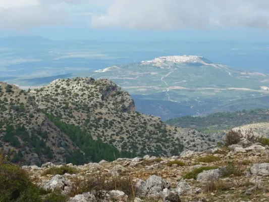
From the top of the Navazalto you will see huge parades of high rocky walls, which cause abrupt and steep ravines, by which spectacular water leaps occur. The panorama is splendid. To the west, the great depression of the Guadalquivir valley, between the green tapestry of the olive trees, is lost on the horizon, as are the villages of the La Loma and Magina. From north to south you can see a complete view of the indomic saw of the Villas, and below, the blue of the reservoir of Aguascebas.
In this place it is easy to observe the flight the leonate vultures, coming out of their nests that are below us. It is also not difficult to see several groups of mountain goats followed by their young.
This route can be done on foot, on a bike or with a 4x4 vehicle. The forest track leading to Navazalto is narrow and sinuous. On the plain, where the track begins, we can see a small fountain with its tornachs, a watershed where the cattle satisfy their thirst. It runs on a soft rocky side with wooded sketches of juniper, savannah, wild rosals and oaks. Later on there are majestic black pine trees that accompany us to the summit, where the pastures are alternated with young pine populations.
Is part of

Datos de la ruta
ROUTE NAME
Pista Forestal de Navazalto
TRAIL TYPE
--
DIFFICULTY
Baja
TOTAL DISTANCE (IN KILOMETERS) --
-
Stretch of asphalt or concrete:
-
Section of track, forest road, or dry watercourse:
-
Trail section:
-
Sections of livestock trails:
HUSO 30S
ESTIMATED TRAVEL TIME
ROAD SURFACE TYPE
Forest track
--
--
DIFFICULTY. RATING ACCORDING TO THE MIDE METHOD
--
MEANS
Severity of the natural environment
--
ITINERARY
Route guidance
--
DISPLACEMENT
Difficulty moving about
--
EFFORT
Amount of effort required
ACCESSIBILITY TYPE
TIME OF YEAR
SIGNALING
No
MORE INFORMATION
TUNNELS
STEEL VIADUCTS
METAL WALKWAYS
WATER POINTS
PONTOONS
GUARD BOOTHS AND BARRIERS
SWITCHMAN'S CABINS
CYCLABILITY
RECREATIONAL OR SPORTS AREAS NEAR THE TRAIL
AID STATIONS
LINKS TO OTHER TRAILS
SHELTERS
RECOMMENDATIONS
OTHER INFORMATION OF INTEREST (ARCHITECTURAL OR HISTORICAL-CULTURAL, GEOLOGICAL-ECOLOGICAL)
Technical Description
To get to the beginning of the track we follow the JH-7155 (Transversal de Las Villas) road, which starts in Mogón, until the km 22, after about 700 m from the site of La Fresnedilla. At that point, to our left, several ways are left. The first to the site of the Arroyo del Torno, place of an old nursery located in the wonderful channel of this stream. The second detour is the track that leads us, after 2.6 km, to the top of Navazalto (1379 m).