


This municipality is part of:
Villacarrillo
A town situated in the east of the district of La Loma y Las Villas, in the northeast of the province, at an altitude of 794 m.
Information
Data of interest
Tourist area Sierras de Cazorla, Segura y las Villas
Distance to the capital (km): 89 84,3
Altitude above sea level (m) 794 785
Extensión (Km2): 240 239,37
No. of Inhabitants 11152 10.726
Demonym Villacarrillenses
Postal Code 23300
Tourist information
Paseo Santo-Cristo
The area around the town can be separated into two well-defined sections. On one side is the area of countryside, raised lands covered in a genuine "sea of olive trees". On the other side, there is the Sierra de las Villas, where the landscape is covered in conifers, scrubland and hills. A number of rivers irrigate the land: The Guadalimar, which serves as a natural border with the district of Condado; the Guadalquivir, which separates the countryside from the sierra, with its two tributaries, the Aguascebas Grande and the Aguacebas Chico. The township of Vallacrrillo is made up of a number of different towns and villages: Villacarrillo, Cabeza de Mogón, La Caleruela, Agrupación de Mogón and Arroturas. The local economy is almost exclusively based on olive farming and Villacarrillo is currently the world's largest producer of olive oil.
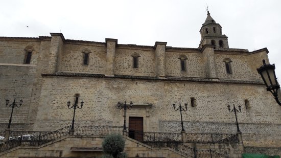
The township also boasts a great and varied historical and artistic heritage. Highlights include the Iglesia de la Asunción (Church of the Assumption), the Iglesia de Santa Isabel de los Ángeles (Church of Saint Elizabeth of the Angels), the Ayuntamiento (Town Hall), the Casa de la Inquisición (House of the Inquisition), the air-raid shelters and numerous palaces and mansions of great artistic interest from different periods.
Source of information
Ayuntamiento de Villacarrillo
Imágenes
Contenido Audiovisual
? ![]()
Destinations
Nature
Culture
Festivities
Destinos
Culture
Nature
Culture
Festivities


Plan your trip
Plan your trip
Discover EXPERIENCES
SCHEDULE Events
SEE MORE
-
Alojam. Rural "Camino del rio"
-
Apartments Cortijo Fuente del Roble
-
Apartments El Molinillo
-
Carnicería y charcutería Hermanos Canales Jiménez
-
Casa Cortijo Las villas sierra
-
Casa de la Inquisición
-
Casa Gilico
-
Casa Rural Aguascebas
-
Casa Rural Collado del Pocico
-
Casa Rural El Duende
-
Casa Rural Huerta de La Pimienta
-
Casa San Francisco
-
Casa-Cortijo Chorrogil
-
La Fresnedilla Astronomy Centre
-
Corpus Christi
-
Cortijo Los Moya
-
Encierro Taurino Villacarrillo
-
Fabrega
-
Finca rústica Miralrio
-
Herrera
-
Hotel Las Villas
-
La Fresnedilla I (Casa del Ingeniero)-II (Casa del Guarda)
-
La Huerta de Carmen
-
La traviesa
-
Mirador de la Osera
-
Notaliv Cosmética Natural
-
Puerta de las Villas
-
Restaurante Asador Trípoli
-
Restaurante El Burladero
-
Restaurante Hotel Sierra de las Villas
-
Restaurante La Fresnedilla
-
Restaurante la Traviesa
-
Restaurante Mesón Rural Verde Oliva
-
Restaurante Parada
-
Restaurante Pizzeria Il Pomodoro
-
Sillero
-
Aventura Las villas
-
Turismo Activo Gesme Acnatu
-
Vacariza
-
Viajes MingoTravel
-
Viajes Sendatur Villacarrillo
-
Viantur Viajes
-
Villacarrillo
-
Villanaturax
-
Vivienda rural El derramadero
-
VTAR "Junto al Guadalquivir"
-
VTAR "Mirador del Guadalquivir"
-
VTAR Doña Maria
-
VTAR Las Castañetas
-
VTAR Majada La carrasca
-
VTAR Senda la berrea


