


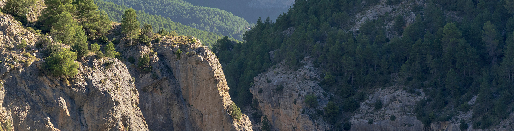
Geology
The mountains of the Park are the best representation of the Prebetic Domain of these mountain ranges, predominantly carbonate rocks, limestones and dolomites, with a great abundance of fossils, and intercalations of marl and detrital levels, mainly sand.
The Formation of the Baetic Cordillera
To understand the geological history of the park, we have to adjust our perspective and think in more abstract terms. The materials that make up these mountains come from sediment located in a large geosyncline, almost the size of an entire region, which existed between the African and Iberian tectonic plates and formed an enormous sea basin during the Mesozoic (from 65 to 251 million years ago) and Cenozoic (from the present day to 65 million years ago) eras. As the crusts of the continents of Europe and Africa moved closer to one another, the mountain ranges were formed by the folding and deformation of undersea material. Sixty-two million years ago the so-called Alpine Orogeny caused mountain ranges such as the Alps and those in the Mediterranean to form, including the mountains that are today located in the natural park.
Within the Baetic Cordillera the natural park lies inside the Prebaetic System, which connects to the geological formations of the central Iberian ...
To understand the geological history of the park, we have to adjust our perspective and think in more abstract terms. The materials that make up these mountains come from sediment located in a large geosyncline, almost the size of an entire region, which existed between the African and Iberian tectonic plates and formed an enormous sea basin during the Mesozoic (from 65 to 251 million years ago) and Cenozoic (from the present day to 65 million years ago) eras. As the crusts of the continents of Europe and Africa moved closer to one another, the mountain ranges were formed by the folding and deformation of undersea material. Sixty-two million years ago the so-called Alpine Orogeny caused mountain ranges such as the Alps and those in the Mediterranean to form, including the mountains that are today located in the natural park.
Within the Baetic Cordillera the natural park lies inside the Prebaetic System, which connects to the geological formations of the central Iberian plateau. The system itself is clearly divided into the Internal Prebaetic and External Prebaetic, a distinction that is defined by the outcropping of materials from the Triassic period uncovered by the Guadalquivir River, the source of the erosion in these mountains.
The Geological History of the Park
During the Palaeozoic Era (from 251 to 542 million years ago), the great syncline that existed in this region folded in on itself as a result of the Hercynian orogeny. Later, a distinction arose between the central Iberian plateau, which was dominated by erosion, and a series of deposits which were to form the Baetic Cordillera.
The Mesozoic Era (from 65 to 251 million years ago) bore witness to a series of geological events that were of great importance in the history of these mountains, as follows:
Triassic Period (from 200 to 251 million years ago): The area was covered by the sea, which led to the creation of clay and sand deposits. At the end of this period the water underwent severe evaporation, which caused lagoons to form and the consequent depositing of materials resulting from the evaporation.
Jurassic Period (from 145 to 200 million years ago): A large part of the basin was still covered by the sea. Materials such as dolomites and marl developed, a ...
During the Palaeozoic Era (from 251 to 542 million years ago), the great syncline that existed in this region folded in on itself as a result of the Hercynian orogeny. Later, a distinction arose between the central Iberian plateau, which was dominated by erosion, and a series of deposits which were to form the Baetic Cordillera.
The Mesozoic Era (from 65 to 251 million years ago) bore witness to a series of geological events that were of great importance in the history of these mountains, as follows:
Triassic Period (from 200 to 251 million years ago): The area was covered by the sea, which led to the creation of clay and sand deposits. At the end of this period the water underwent severe evaporation, which caused lagoons to form and the consequent depositing of materials resulting from the evaporation.
Jurassic Period (from 145 to 200 million years ago): A large part of the basin was still covered by the sea. Materials such as dolomites and marl developed, and were raised up towards the end of this period.
Cretaceous Period (from 65 to 145 million years ago): Approximately halfway through this period a great marine irruption occurred, forming a number of coral reefs and generating a shallow yet distinctly marine environment. As the water receded, deposits of limestone and dolomites were left behind. During the Cenozoic Era (from the present day to 65 million years ago), the following geological events occurred:
Palaeogene Period (from 23 to 65 million years ago): The seawater withdrew, once again leaving lagoons formed by the water accumulated during the preceding period. At the end of the Palaeogene Period a thrust fault occurred towards the northeast, resulting in folding and erosion across the region.
Neogene Period (from 2 to 22 million years ago): Another marine irruption occurred, which, more importantly, caused a period of geological instability that led to a sub-baetic thrust fault and Prebaetic folding. This extraordinarily slow process, which continues today, involves the compression of sediment which then deforms, fractures and piles up in tectonic units that eventually rise out of the sea.
Quarternary Period (from the present day to 2 million years ago): The current terrain of the park's mountain ranges took shape. The land rose by around 1,000 metres, which boxed in the rivers and caused them to erode a passage through the landscape that led to the present-day configuration of the park, forming the smoother, more compact Segura mountains and the more jagged Las Villas and Cazorlas ranges.


