


Segura de la Sierra - Refugio CF El Campillo

This short stage, which runs mostly through old traditional paths, allows you to enjoy the transition between the humanized landscapes of the low mountains and the closed forest masses of the high areas, getting to know the three types of pine forests that follow one another in the park natural as we gain altitude: those of Carrasco, Negral and Laricio or Salgareño.
The route starts from Segura de la Sierra, a small white town hanging on the mountain, whose restored Arab castle testifies that this town was the historical head of the Sierra de Segura region. Go down between pines and holm oaks to the pleasant Trujala Valley and the village of the same name, with a scattered settlement, where pine forests, rocky areas, mountain olive groves, orchards and small farmhouses are harmoniously combined.
After passing very close to the Moro Bridge and the Roman bridge of Romillán, we will ascend to the Dehesa de la Carnicera, changing the environment and entering a valuable and cozy black pine forest with an abundance of holm oaks, gall oaks and junipers. The stage ends at the El Campillo ...
This short stage, which runs mostly through old traditional paths, allows you to enjoy the transition between the humanized landscapes of the low mountains and the closed forest masses of the high areas, getting to know the three types of pine forests that follow one another in the park natural as we gain altitude: those of Carrasco, Negral and Laricio or Salgareño.
The route starts from Segura de la Sierra, a small white town hanging on the mountain, whose restored Arab castle testifies that this town was the historical head of the Sierra de Segura region. Go down between pines and holm oaks to the pleasant Trujala Valley and the village of the same name, with a scattered settlement, where pine forests, rocky areas, mountain olive groves, orchards and small farmhouses are harmoniously combined.
After passing very close to the Moro Bridge and the Roman bridge of Romillán, we will ascend to the Dehesa de la Carnicera, changing the environment and entering a valuable and cozy black pine forest with an abundance of holm oaks, gall oaks and junipers. The stage ends at the El Campillo Forest House, in the middle of the black pine forest. From there we have several options, all by signposted routes: continue towards Hornos de Segura along the GR 247 Bosques del Sur trail; climb to the summit of El Yelmo or go down to the enchanting valley of the Madera River.
This stage offers you the connection with the GR 247.1 variant. If you choose the variant you can connect with stages 19 and 20 and following. So you can do a smaller circuit than the main one, with the northern stages of the trail.
Technical information
Route Name Rutas Bosques GR247
Rutas Bosques GR247 2: Segura de la Sierra - Refugio CF El CampilloHUSO 30S
Segura de la Sierra: x530477 y4239070
Refugio C.F. El Campillo: x530647 y4233365
Segura de la Sierra: x530365 y4238862
Refugio C.F. El Campillo: x530535 y4233157
TOTAL DISTANCE (IN KILOMETERS)9950
Asphalt or cement section 18,19 %
Section of track or forest road or promenade 6,03 %
Senda section 75,78 %
tramos-de-Vía-pecuaria 0%
ESTIMATED RUN TIMEO
4 hMAXIMUM SLOPE674 m
DIFFICULTY. ASSESSMENT ACCORDING TO METHOD MEASURE
2
MEDIO.
Severity of the natural environment
2
Itinerary
Orientation in the itinerary
2
Displacement
Difficulty moving
3
EFFORT.
Amount of effort required
TOTAL DISTANCE (IN KILOMETERS) 19540 M
Start
Segura de la Sierra: JA-9117 road from Orcera; or JA-9118 road if we come from Hornos on the A-317.
Final
El Campillo Forest House Refuge: from Segura de la Sierra, along the Sierra road and then along the JF-7016 to the right; from Río Madera: on the road to Hornos de Segura and then on the JF-7016 to the right.
INTERMEDIATE POINTS
PLACE
POSITION
TYPE OF ROAD
Km 1,9
Highway
CYCLABILITY
Almost the entire Stage runs along a path, with rocky spots and short sections with steep slopes.
WATER POINTS
Segura de la Sierra, Trujala, Fuente del Avellanar
PREFRESHING POINTS
On the trail: Segura de la Sierra
Near the trail: Orcera and Cortijos Nuevos
LINKS WITH OTHER TRAILS
GR 147, PR-A 194
Rutómetro
Segura de la Sierra
We start from Segura de la Sierra from the Puerta de Catena, a few meters from the Arab Baths. These two constructions create an environment that clearly evokes that of the northern Maghreb peoples. The views towards mountains and olive groves are vast. We go down 50 meters to the road, along which we walk about 200 meters and continue to the left along the path that goes down to the Trujala Valley. It is a delicious traditional path that runs through dense Mediterranean forest dotted with small olive groves.
Trujala Valley
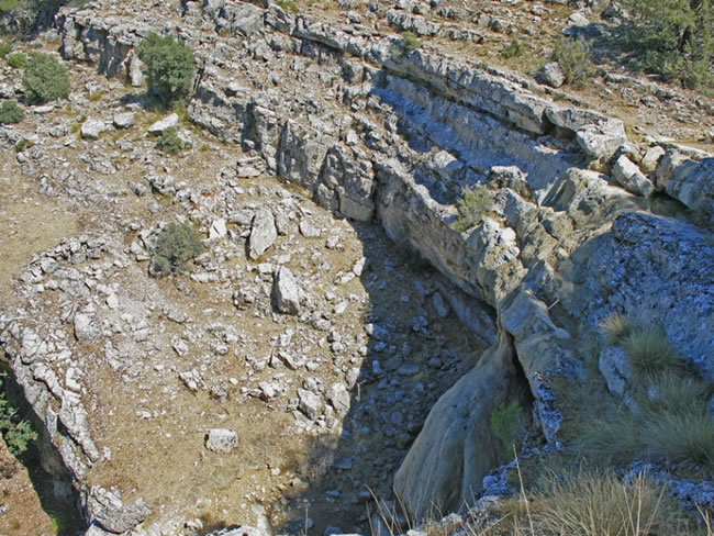
We arrive at the narrow Valle del Trujala, which is a tributary of the Guadalimar. In this place the little road that we see on our right ends, which runs through the valley and its small villages, such as Puente Moro, El Batán, El Porche, Don Lope, El Soto, etc. With its scattered settlement, its white farmhouses and its riverside vegetation, the Trujala Valley is one of the areas in this part of the natural park where the traditional environment is best preserved. In addition, the area in which our route crosses the Trujala Valley has a notable archaeological relevance, because in it is the so-called Moro Bridge, near the path. It is a wide bridge of medieval origin, very close to which there is a smaller one, which is attributed Roman origin, called Puente de Romillán.
Arroyo de Los Yeros
We cross the Arroyo de Los Yeros –a tributary of the Trujala– and go on to walk along a path, which in some of its first sections is rocky. Immediately we come to a crossroads with directional signs to which we must be attentive.
Our path rises and enters a pine forest of Aleppo pine with an abundance of rosemary and blackberry juniper. Below we will see the Cortijo de Romillán. Behind us, to the left, appears the castle of Segura de la Sierra, and later, to the right, El Yelmo. Further on our path widens, while to the left there are beautiful panoramic views towards the Navalperal cove. Soon the undergrowth will become more shady and leafy, with holm oaks, strawberry trees, junipers and cornicabras. At kilometer 3.8 we come to a clearing in the forest with some reed beds that must be crossed by looking at the signaling beacons. At approximately kilometer 4.8 we will have already passed the stratum of the black pine and the undergrowth is still very closed.
Crossing with forest track
We cross a wide forest track that comes from the Casa Forestal de Navalcaballo and goes down to the village of El Robledo. We observe that now there are more oaks. A little further up, if we look back, we will enjoy great views over the lowlands of the Guadalimar Valley, covered with olive groves, and of Segura de la Sierra. After crossing a stream, the path gains height by zigzagging for a steep stretch. We are now entering the domain of large, straight, salgareño pines, and the soil becomes more grassy.
Chorreón de la Cañada de la Fresnadilla
To our left, below, there is a wide rocky and stepped amphitheater, under which there is a tuff through which the water falls, called Chorreón de la Cañada de la Fresnadilla. It often dries up, but if we are lucky enough to see it with water and when the room temperature is right, it is an excellent place to take an impromptu mountain shower. Afterwards, we flatten through a poplar grove with very grassy soil, beautiful in autumn.
Road junction
We cross the JF-7016 road. Our route ascends through the Cañada del Borriquillo where, as it is a livestock route, the path is not very defined, but the marks and beacons leave no room for doubt. At kilometer 7.5 our route separates from GR 147, with which it has coincided until now. We will come to a clearing, which is a wide hill. From it, surprising views open to the east, specifically towards the Cerro del Toril and the Loma del Mirandante. Below is the valley of the Madera River. We continue, seeing the mass of El Yelmo in front, and then we flatten through the pastures of El Campillejo, following the marks and beacons, until we reach the road again.
Road junction
During the last kilometer and a half of our stage we will walk along the narrow JF-7016 road, without slope, flanked by El Yelmo and the wide pastures of El Campillejo, and in the middle of an open and magnificent landscape. At kilometers 9 and 9.4 we will see two roads signposted to the right that converge at Fuente del Avellanar. It is important to stock up on water, because the refuge where the stage ends does not have a source. The first of these roads is 150 meters long and the second 300 meters.
El Campillo Forest House Refuge
The stage ends at the El Campillo forest house, located at the southeastern base of El Yelmo. The old house where the forest ranger lived is in ruins, but its size and the existence of several auxiliary buildings give an idea of ??the importance it had at the time, which is logical given the traditional forest relevance of the entire area. In one of these units is the shelter where we can spend the night. The closest water point is the Avellanar fountain. To get there we must go along the road - Segura de la Sierra direction - and after about 600 meters take the signposted path that we have commented before, and that we will now find on the left. From there, the fountain is 300 meters away.
El Campillo is not only a place of great beauty, but also a strategic point to start several hiking routes. Obviously, we can continue along the GR 247 doing stage 3, which reaches Hornos de Segura. But you can also choose to go up to the Cumbre de El Yelmo –one of the best viewpoints in the north of the park– throu ...
El Campillo Forest House Refuge
The stage ends at the El Campillo forest house, located at the southeastern base of El Yelmo. The old house where the forest ranger lived is in ruins, but its size and the existence of several auxiliary buildings give an idea of ??the importance it had at the time, which is logical given the traditional forest relevance of the entire area. In one of these units is the shelter where we can spend the night. The closest water point is the Avellanar fountain. To get there we must go along the road - Segura de la Sierra direction - and after about 600 meters take the signposted path that we have commented before, and that we will now find on the left. From there, the fountain is 300 meters away.
El Campillo is not only a place of great beauty, but also a strategic point to start several hiking routes. Obviously, we can continue along the GR 247 doing stage 3, which reaches Hornos de Segura. But you can also choose to go up to the Cumbre de El Yelmo –one of the best viewpoints in the north of the park– through the PR-A 194, signposted and which is also part of the Bosques del Sur trail as derivation 2. Or You can go down to the valley of the River Madera by the path that starts on the other side of the road, right in front of the refuge. This path is recovered and marked by the Segura Hydrographic Confederation. It is 4.8 km long and has a negative total elevation gain of 230 meters. It runs through beautiful forests and, at the end, passes next to the village of Arroyo Canales (Madera river), where we can connect with the GR 247.1 variant of the Bosques del Sur trail. Although this variant does not link here with this part of the trail, a small displacement would allow you an alternative route, using the variant to return to Segura de la Sierra by another path, or connect directly with the stages of the interior of the Sierra de Segura.
Additional information
The five doors of Segura de la Sierra
The entrance portico to Segura de la Sierra for most visitors, who arrive by road, is the splendid Puerta Nueva, which seems to date from the s. XVI and that replaced a previous one of which only the left tower remains. But today, by recovering the use of the old roads, we re-enter through almost forgotten doors, made to defend the town in times when there were no walkers or equestrian tourists, but walkers and horsemen. Or, simply, villagers descending to their hidden gardens on donkeys.
Thus, the Bosques del Sur trail passes through two of its doors. If we come from doing stage 1 we enter through the Puerta de Orcera, which was part of the old Arab wall and today is crying out for restoration. If we leave at the other end of the town to do stage 2 towards the Trujala valley and El Campillo, we will pass through the Puerta de Catena, which was partially restored in 1972 and retains the authentic appearance of a medieval Muslim gate. It is included in a very rarely visited tower, inside which, ...
The five doors of Segura de la Sierra
The entrance portico to Segura de la Sierra for most visitors, who arrive by road, is the splendid Puerta Nueva, which seems to date from the s. XVI and that replaced a previous one of which only the left tower remains. But today, by recovering the use of the old roads, we re-enter through almost forgotten doors, made to defend the town in times when there were no walkers or equestrian tourists, but walkers and horsemen. Or, simply, villagers descending to their hidden gardens on donkeys.
Thus, the Bosques del Sur trail passes through two of its doors. If we come from doing stage 1 we enter through the Puerta de Orcera, which was part of the old Arab wall and today is crying out for restoration. If we leave at the other end of the town to do stage 2 towards the Trujala valley and El Campillo, we will pass through the Puerta de Catena, which was partially restored in 1972 and retains the authentic appearance of a medieval Muslim gate. It is included in a very rarely visited tower, inside which, with a little imagination, we can evoke the similar corners that still exist today in many Maghreb towns.
From the Puerta de Góntar, which at the time controlled the entrance from the mountains, there is only a little recognizable tower, enabled as a first-aid kit for the bullring, on the path that goes up to the castle. And only part of the foundation remains of the Puerta Herrada. Thus, in the times of the Muslims, for whom the importance of the medinas was related to the number of their gates, Segura de la Sierra had five, a not inconsiderable number.

Follow us #JaénParaísoInterior


