


La Toba - Prado Maguillo y Refugio Casa Forestal El Bodegón

This stage is short but intense due to the amount and variety of incentives it has, so that the walker's efforts will be more than compensated. Going through it, you can enjoy great panoramic views from the highest points, immense black pine forests and small villages of white houses, lost in the mountains, authentic bastions still alive of the traditional life of the Andalusian high mountains, such as La Toba (with a powerful water source in a cave), the Fuente del Esparto, Los Anchos or Prado Maguillo, the latter two in a delightful valley a thousand times photographed and with a fairly well preserved popular architecture.
The route jumps from the valley of the river Segura to that of the Arroyo de Los Anchos, the latter even more narrow and lonely than the former. After crossing the river Segura, we will visit tiny villages, some of them already uninhabited. Afterwards, we will ascend through pine forests –overflown by the common vulture and the golden eagle– to the spectacular Paso de la Viga, a narrow gate in the rock behind which an unexpected natural balcony opens towards the Valle ...
This stage is short but intense due to the amount and variety of incentives it has, so that the walker's efforts will be more than compensated. Going through it, you can enjoy great panoramic views from the highest points, immense black pine forests and small villages of white houses, lost in the mountains, authentic bastions still alive of the traditional life of the Andalusian high mountains, such as La Toba (with a powerful water source in a cave), the Fuente del Esparto, Los Anchos or Prado Maguillo, the latter two in a delightful valley a thousand times photographed and with a fairly well preserved popular architecture.
The route jumps from the valley of the river Segura to that of the Arroyo de Los Anchos, the latter even more narrow and lonely than the former. After crossing the river Segura, we will visit tiny villages, some of them already uninhabited. Afterwards, we will ascend through pine forests –overflown by the common vulture and the golden eagle– to the spectacular Paso de la Viga, a narrow gate in the rock behind which an unexpected natural balcony opens towards the Valle de Los Anchos.
From there we descend to cross the placid fields of work, many of them abandoned but dotted by small poplar groves that add warm yellow touches in autumn. The villages of Los Anchos and Prado Maguillo seem suspended in the past, and in them we will be able to notice many details of the traditional mountain architecture, in addition to leisurely recreating ourselves in the view of this secluded valley embedded in the high mountains. It is interesting to visit the surprising Alma Serrana Ethnological Collection, located in an environment of great landscaping quality and which houses an endless number of objects belonging to all traditional trades.
Also at the beginning of this stage you can enjoy derivation 7 of the GR 247, which walks along the shores of the mysterious Las Anchuricas reservoir. The end of the stage coincides with the beginning of the GR 247.1 variant that connects in two days with stages 1 and 2 in Segura de la Sierra.
Technical information
Route Name Rutas Bosques GR247
Rutas Bosques GR247 19: La Toba - Prado Maguillo y Refugio Casa Forestal El BodegónHUSO 30S
La Toba: x538617 y4225989
Prado Maguillo: x537248 y4231561
La Toba: x538505 y4225782
Prado Maguillo: x537136 y4231354
TOTAL DISTANCE (IN KILOMETERS)9600
Asphalt or cement section 8,33 %
Section of track or forest road or promenade 45,31%
Senda section 46,36 %
tramos-de-Vía-pecuaria 0 %
ESTIMATED RUN TIMEO
3 h 30 minMAXIMUM SLOPE562 m
DIFFICULTY. ASSESSMENT ACCORDING TO METHOD MEASURE
2
MEDIO.
Severity of the natural environment
2
Itinerary
Orientation in the itinerary
2
Displacement
Difficulty moving
3
EFFORT.
Amount of effort required
TOTAL DISTANCE (IN KILOMETERS) 19540 M
Start
La Toba is accessed from Juntas de Miller and from Río Madera by the JF-7038 that runs through the Segura River Valley.
Final
La Toba is accessed from Juntas de Miller and from Río Madera by the JF-7038 that runs through the Segura River Valley.
INTERMEDIATE POINTS
PLACE
POSITION
TYPE OF ROAD
Km 2,4
Highway
Km 8,1
Highway
CYCLABILITY
Almost half of the Stage is carried out along paths, in which there are short sections with steep slopes and uneven ground. The Paso de la Viga is not cyclable, which means about 400 meters.
WATER POINTS
La Toba, La Peruela, Los Anchos, Prado Maguillo
PREFRESHING POINTS
On the trail: La Toba
Near the trail: no
LINKS WITH OTHER TRAILS
PR-A 100, PR-A 128, GR-147
Rutómetro
The Toba
The stage begins next to the initial information panel that is on the outskirts of the village of La Toba, very close to the Segura river, whose bridge we cross to reach the JF-7038 road a few meters. We turn right, in the direction of Las Juntas de Miller, and walk about 650 meters along the road, seeing to our right and on the opposite slope several waterfalls from La Toba, which pour their waters into the Segura River. We take the path that goes up to the left, very close to the village of Casicas del Río Segura, which is on the right.
The path leads to a semi-abandoned forest track fork. We continue to the left, practically in the same direction in which we are traveling and we continue climbing. This track, further up, on a small hill, is already in a better state of conservation and we continue it without deviating 100 meters to reach another track that climbs to the left and maintains the altitude. We continue to lead.
We come to another track junction, which is paved; we must take to the left. A few meters away we pass a fence and several inhabited houses to the right, which make up the small village of La Garganta. We are in the middle of a pine forest dotted with some gall oaks, but it is also a landscape in which there are many testimonies of human intervention, such as abandoned terraces and orchards. We will continue along this track to where it ends, next to the village of La Fuente del Esparto.
Cortijo de La Peruela
We arrive at the farmhouses of La Peruela, practically a neighborhood in the village of La Fuente del Esparto, which is a little further down and to the right. In La Peruela we find orchards, a stream with well-preserved riverside vegetation and a small viewpoint. Before the mentioned stream there is a path to the right that goes down to the village of La Fuente del Esparto. It is advisable to get away from the route and go along it to take a quiet walk through this village, with somewhat scattered houses, and where you can breathe the tranquility and authenticity of the rural mountain environment of the Sierra de Segura.
Returning to our route, we continue along the track in front, immediately passing a stream and arriving at the village of Los Galdones, where the track becomes a path. We see small farmhouses, some already in ruins, as well as terraces, poplars, walnut trees, fig trees and other fruit trees, as well as a traditional lavadero fountain painted in blue. The path goes into the forest, but a few m ...
Cortijo de La Peruela
We arrive at the farmhouses of La Peruela, practically a neighborhood in the village of La Fuente del Esparto, which is a little further down and to the right. In La Peruela we find orchards, a stream with well-preserved riverside vegetation and a small viewpoint. Before the mentioned stream there is a path to the right that goes down to the village of La Fuente del Esparto. It is advisable to get away from the route and go along it to take a quiet walk through this village, with somewhat scattered houses, and where you can breathe the tranquility and authenticity of the rural mountain environment of the Sierra de Segura.
Returning to our route, we continue along the track in front, immediately passing a stream and arriving at the village of Los Galdones, where the track becomes a path. We see small farmhouses, some already in ruins, as well as terraces, poplars, walnut trees, fig trees and other fruit trees, as well as a traditional lavadero fountain painted in blue. The path goes into the forest, but a few meters later we find the old Los Galdones era on the left. The threshing floors are always in well open and ventilated places, because in them, after threshing to separate the grain from the straw from the cereal, it was necessary to winnow the latter. In Los Galdones we must make a stop to calmly contemplate the extraordinary landscape that opens before us to the east and south. The great forests that extend under strong rocky outcrops preside over the panorama. We can see the Segura valley splitting the mountains, among which the Umbría de Los Anguijones and the Poyos de La Toba stand out, crowned by the Puntal de las Buitreras, so called because in the cliffs below it there are numerous holes used by the vultures to nest or rest. As we move through the era, our footsteps lift the fragrant scent of marjoram.
We continue up the path, observing the abundance of holm oaks that mix with the pines, and at kilometer 3 we come out onto the forest track, which we take to the right. Some paratas (dry stone walls) testify that in the past any piece of fairly flat land was used to sow cereals. To the right we can see the high cliffs that crown the Calar del Cobo, to whose summit, the Puntal de la Misa, leads up to bypass 8, one of the most spectacular on the Bosques del Sur trail. Our track passes through a dense forest of black or salgareño pines with holm oaks and gall oaks. From time to time we see specimens of maple and blackberry juniper. The fencing that we see in some sections corresponds to an area where truffles are grown.
Cortijos de Los Paulinos
Our route then passes next to the Los Paulinos farmhouses, which are on the right, nestled in one of the most spectacular places in the Sierra de Segura. They are already abandoned, although we can still enjoy the presence of the beautiful walnut trees planted by their former inhabitants. We leave the track to take an old path that starts to the left, about 100 meters before an era (the "one below"), gaining wonderful views over the Segura valley and the great rocky mass of Puntal de la Misa, as we can check into the new era (the "above") we are going through. The path zigzags through the black pine forest, then turns west to face the rocky wall of the Cordon del Mosco, which at first seems difficult to cross.
Beam Pass
The path climbs through increasingly rocky terrain and reaches a point where its continuity would not be possible were it not for the skillful and hard work of the ancient inhabitants of the area who, in Paso de la Viga, erected a last or dry stone wedge (that is, without mortar, as would be the case with masonry) several meters high to support the path while they excavated the rock face along several meters so that there was enough hole to be able to pass. The effort to build this pass was worth it, because the relationship between the Segura valley and the Los Anchos valley was intense when all the villages and farmhouses were populated and it was essential that there should be at least one place where the horse could pass without take great detours. Thanks to Paso de la Viga, the inhabitants of both valleys always maintained fluid relationships, both commercial, personal and family. There were, and still are, other passes between the two valleys, but they could only be covered on foot.
The route winds between cliffs on ...
Beam Pass
The path climbs through increasingly rocky terrain and reaches a point where its continuity would not be possible were it not for the skillful and hard work of the ancient inhabitants of the area who, in Paso de la Viga, erected a last or dry stone wedge (that is, without mortar, as would be the case with masonry) several meters high to support the path while they excavated the rock face along several meters so that there was enough hole to be able to pass. The effort to build this pass was worth it, because the relationship between the Segura valley and the Los Anchos valley was intense when all the villages and farmhouses were populated and it was essential that there should be at least one place where the horse could pass without take great detours. Thanks to Paso de la Viga, the inhabitants of both valleys always maintained fluid relationships, both commercial, personal and family. There were, and still are, other passes between the two valleys, but they could only be covered on foot.
The route winds between cliffs on an unconsolidated surface, with quite a few loose stones, so special caution must be exercised. In addition, during part of the year a small stream runs down, which can sometimes freeze. If we look back, the views towards the Segura valley will force us to stop in admiration. Finally we come out of the crevasse and just 200 meters away the climb up the hill ends. From here the path smooths out and flattens out in the middle of a splendid natural balcony with no less astonishing views. To our right, on the other side of the mountain, are the cliffs of Poyo Gavilán and the La Raja pass, similar to that of La Viga but even narrower, and through which our route does not go.
Very soon we will enjoy the vision of the spectacular valley of Los Anchos, with the village of the same name and others such as Majada Oscura and Prado Maguillo, against the backdrop of Loma del Mirandante and the creeks of Peña Rubia and El Espino. From here to Los Anchos, although the route is perfectly signposted, you have to be especially aware of the marks and beacons.
After descending a stretch of still rocky terrain, the path enters the pine forest and becomes wider and more comfortable, although it holds fewer emotions. Shortly before reaching the bottom of the valley, in a wide clearing in the forest and after having traveled just over a kilometer and a half from Paso de la Viga, we passed the small Los Anchos cemetery, which is on our left. It is a moving place whose low walls allow us to peek into the enclosure and see the simple tombs, without niches or tombstones, where the remains of the highlands and highlands that for so long lived off the resources of this mountain valley lie, thus creating the harmonious landscape that we now enjoy.
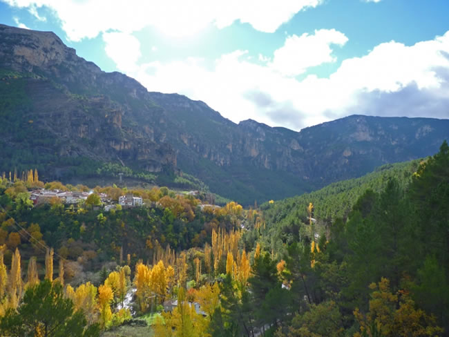
Shortly after, we left the forest and arrived at the delicious Los Anchos plain, with terraces, orchards (most of them uncultivated), apple trees and small poplar trees that in autumn give the yellow touches that so beautify this place. We cross the Los Anchos stream over a bridge and continue following the beacons, reaching the village a hundred meters later.
The Widths
This village deserves a leisurely walk to contemplate its well-preserved popular architecture, like that of the nearby villages, in addition to its beautiful views. We will discover the laundry room, the hermitage and the old restored communal oven.
It is essential to deviate from the route to go down the valley road, to the left, to the neighboring village of Majada Oscura, which can be reached in a few minutes and where the Alma Serrana Ethnographic Collection is located. Despite its limited space, it houses a large collection of ancient objects of daily use in traditional mountain life, and it is in an absolutely surprising place, where you would not expect to find something like this. It transmits authenticity, not only for the pieces it exhibits, but also for the traditional farmhouse it occupies and for the extraordinary landscape of which it is part. The house-museum offers us a journey through different aspects of traditional life, such as the rooms of the mountain house, the rural school, the barber shop, the ol ...
The Widths
This village deserves a leisurely walk to contemplate its well-preserved popular architecture, like that of the nearby villages, in addition to its beautiful views. We will discover the laundry room, the hermitage and the old restored communal oven.
It is essential to deviate from the route to go down the valley road, to the left, to the neighboring village of Majada Oscura, which can be reached in a few minutes and where the Alma Serrana Ethnographic Collection is located. Despite its limited space, it houses a large collection of ancient objects of daily use in traditional mountain life, and it is in an absolutely surprising place, where you would not expect to find something like this. It transmits authenticity, not only for the pieces it exhibits, but also for the traditional farmhouse it occupies and for the extraordinary landscape of which it is part. The house-museum offers us a journey through different aspects of traditional life, such as the rooms of the mountain house, the rural school, the barber shop, the old inn, the stable and the trades related to the forest.
From Los Anchos, the Bosques del Sur trail continues along the paved forest track that leaves the upper part of the village, a few meters from the hermitage and the laundry, towards the hamlet of Prado Maguillo. What remains is a pleasant gently ascending walk between pine trees, holm oaks, poplars and small meadows, with stretches that have good views of the valley.
Prado Maguillo
The stage ends in this delightful village, which is smaller than Los Anchos, but which also preserves the popular architecture well and has a somewhat higher position, which makes it an unforgettable viewpoint over the valley. Prado Maguillo is also one of the most strategic places on the Bosques del Sur trail, as it is the beginning or end of three stages: stage 19, which we have just described; 20, through which we reach the refuge of the Era del Fustal, and stage 1 of the GR 247.1 variant, which goes to the valley of the Madera river.
In Prado Maguillo and Los Anchos there is an offer of rural tourism, although it is limited, which may make it advisable that we reserve in advance because they are very small villages. There is the alternative possibility of spending the night in the shelter of the Casa Forestal El Bodegón, located 1.4 kilometers from Prado Maguillo. To get to it, you have to leave the village along the forest track along which stage 1 of the Variante GR 247.1 runs, which goes towards the Madera River and is indicated with directional signs. Once 750 meters have been traveled, take a detour to the left, also signposted, which leads us to the refuge after another 650 meters. It occupies one of the auxiliary buildings of the old forest house. Both this and the warehouse - which was called the barraca - are already in ruins, but the place, which is a wide clearing in the middle of the forest, is charming.
Additional information
Elizabethan butterfly, the flying emerald
The black pine forests of the natural park, like the ones we see at this stage, are the habitat of a butterfly that is considered the most beautiful in Europe. It is about the Elizabethan butterfly (Actias isabellae), so named because its discoverer for science, the doctor and naturalist Mariano de la Paz Graells, dedicated his find to Queen Elizabeth II in 1848. It is impressive for its size, since it can reach 9 centimeters with wings spread, but above all for the spectacular design and color of its wings. These are an intense emerald green, with striking ocelli of various colors and elegant reddish veins. Males have a kind of tail on their hind wings, as well as striking feathery antennae that help them detect the presence of pheromones, chemicals produced by females to attract them sexually.
It is a nocturnal species whose adults fly for a few days during the months of April to June. Sometimes it is found perched and immobile in broad daylight in towns and farmhouses. This is because it ...
Elizabethan butterfly, the flying emerald
The black pine forests of the natural park, like the ones we see at this stage, are the habitat of a butterfly that is considered the most beautiful in Europe. It is about the Elizabethan butterfly (Actias isabellae), so named because its discoverer for science, the doctor and naturalist Mariano de la Paz Graells, dedicated his find to Queen Elizabeth II in 1848. It is impressive for its size, since it can reach 9 centimeters with wings spread, but above all for the spectacular design and color of its wings. These are an intense emerald green, with striking ocelli of various colors and elegant reddish veins. Males have a kind of tail on their hind wings, as well as striking feathery antennae that help them detect the presence of pheromones, chemicals produced by females to attract them sexually.
It is a nocturnal species whose adults fly for a few days during the months of April to June. Sometimes it is found perched and immobile in broad daylight in towns and farmhouses. This is because it is attracted to white light bulbs, being helpless if daylight strikes it away from the pines, which is dangerous for a species that is not abundant. In times past, the species suffered in Spain the harassment of collectors, and later the disastrous consequences of the indiscriminate use of chemical substances to combat the plague of the pine processionary.
In its caterpillar phase it feeds exclusively on pine needles, so this species only lives in pine forests, specifically in pine forests of black, wild and black pine of the Pyrenees, the Iberian System, the Sierra de Guadarrama and the massif formed by the mountains of the natural park and the neighboring Sierra de Alcaraz.

Follow us #JaénParaísoInterior


