


Área Recreativa de Los Parrales - Casa Forestal Hoya de los Trevejiles

Throughout this stage you can enjoy spectacular views of the great El Tranco reservoir and great panoramic views of the Sierras de Segura and Las Villas.
The route starts near the Los Parrales Recreational Area, an excellent place to enjoy contemplating the magnificent landscape formed by the waters of the reservoir and the high mountains that surround it. It passes through extensive forests of black pine in whose shade grows a dense Mediterranean undergrowth, with juniper, blackberry juniper, various species of rockrose and aromatic bushes, such as rosemary, thyme and marjoram.
A small part of the stage brings us closer to the cattle culture and the hard work of the transhumant shepherds, since it runs along a livestock route. Some flocks of Segureña sheep from the municipality of Santiago-Pontones still circulate through it, continuing their annual journey from the green pastures of the high mountains of the natural park to the eastern foothills of Sierra Morena, in the El Condado region.
Shortly before kilometer 7 there is a 1.4-kilometer signposted detour that leads to ...
Throughout this stage you can enjoy spectacular views of the great El Tranco reservoir and great panoramic views of the Sierras de Segura and Las Villas.
The route starts near the Los Parrales Recreational Area, an excellent place to enjoy contemplating the magnificent landscape formed by the waters of the reservoir and the high mountains that surround it. It passes through extensive forests of black pine in whose shade grows a dense Mediterranean undergrowth, with juniper, blackberry juniper, various species of rockrose and aromatic bushes, such as rosemary, thyme and marjoram.
A small part of the stage brings us closer to the cattle culture and the hard work of the transhumant shepherds, since it runs along a livestock route. Some flocks of Segureña sheep from the municipality of Santiago-Pontones still circulate through it, continuing their annual journey from the green pastures of the high mountains of the natural park to the eastern foothills of Sierra Morena, in the El Condado region.
Shortly before kilometer 7 there is a 1.4-kilometer signposted detour that leads to Risca del Guijarrón (or Quijarón), an essential ascent because the views are unforgettable.
The stage ends at the Hoya de Los Trevejiles forest house, which is impressive because in its good days it was one of the most luxurious of these mountains, as attested by its spaciousness, its garden areas and its swimming pool, now in disuse, with a marked style pop. All this, together with the abundance of water and its magnificent views, make it a perfect place to rest after the hike, although it must be remembered that there is no refuge enabled, so it is necessary to remember what is expressed in the section dedicated to the overnight stay, camping and bivouac of the chapter «To enjoy the GR 247 Bosques del Sur trail». It is also advisable to inquire about the possibility of finding accommodation in the vicinity.
Technical information
Route Name Rutas Bosques GR247
Rutas Bosques GR247 5: Área Recreativa de Los Parrales - Casa Forestal Hoya de los TrevejilesHUSO 30S
Área Recreativa Los Parrales: x519841 y4226353
Casa F. Hoya de los Trevejiles: x515603 y4226787
Área Recreativa Los Parrales: x519729 y4226146
Casa F. Hoya de los Trevejiles: x515491 y4226580
TOTAL DISTANCE (IN KILOMETERS)17500
Asphalt or cement section 0%
Section of track or forest road or promenade 77,14 %
Senda section 9,72 %
tramos-de-Vía-pecuaria 13,14 %
ESTIMATED RUN TIMEO
5h 45 minMAXIMUM SLOPE543 m
DIFFICULTY. ASSESSMENT ACCORDING TO METHOD MEASURE
2
MEDIO.
Severity of the natural environment
2
Itinerary
Orientation in the itinerary
2
Displacement
Difficulty moving
3
EFFORT.
Amount of effort required
TOTAL DISTANCE (IN KILOMETERS) 19540 M
Start
The Parrales Recreational Area, located between the Tranco Dam and the village of Cañada Morales, is reached through a 300-meter forest track that starts from the A-319 road.
Final
The Hoya de los Trevejiles Forest House is accessed by a short paved forest track from the A-6202 road, which connects Villanueva del Arzobispo with the Tranco Dam.
INTERMEDIATE POINTS
PLACE
POSITION
TYPE OF ROAD
Km 10,5
Forest track
CYCLABILITY
The section by cattle track between kilometers 8 and 10.5 is not recyclable.
WATER POINTS
Los Parrales Recreation Area, Los Parrales watering hole, Gollete stream watering hole, Hoya de los Trevejiles Forest House
PREFRESHING POINTS
On the trail: Hornos de Segura, Cortijos Nuevos.
Near the trail: No
LINKS WITH OTHER TRAILS
GR 144
Rutómetro
Risca del Guijarrón track
From the A-319 road, between the entrance to the Los Parrales rural house and the Montillana campsite, the path begins along a narrow forest track in a northwesterly direction, with various signs in the place. Some sections of this road are closed to motor vehicle traffic by means of a chain, being a little traveled, winding and almost always uphill road that runs along the eastern face of Risca del Guijarrón, a mountain well known in this area and strategically located on the dam of the El Tranco reservoir. The vegetation that we find at the beginning is that of the lower areas of the natural park, with a milder climate, that is, Aleppo pine forests, with holm oaks, rosemary, mastic, kermes oak, juniper, blackberry juniper and various species of rockrose.
At 500 meters from the start we cross a small plain known as La Hoya de los Conejos, and from here a somewhat steeper climb begins. The track in some sections is quite stony due to the rocky nature of the substrate in the area.
Fountain of the Parrales
To the left of the path we find one of the drinking fountains built by the now defunct ICONA. It should be taken advantage of because until kilometer 13.5 we will not find another source.
Fork
At the first bifurcation of tracks that we find, we must take the one on the right, since the one on the left ends at 500 meters and the tinada de Los Parrales serves as access. The views over the El Tranco reservoir, and over the mountains that surround us, as we ascend, begin to be impressive. Soon we see the first black pines, typical of the altitudinal strip that we reached. To the left, in the middle distance, we leave the Lancha del Guijarrón, while in the distance we see some antennas and a white house on top that indicate the location of the Risca del Guijarrón peak.
At kilometer 5 we pass a hill, and just at that point we also cross a firebreak, finding ourselves already at an altitude of 1150 meters.
Fork
New fork in the tracks where we must take the one on the left. On the right we can see at the top of a hill the fire guardhouse known as La Bandera, on Cerro Peguera, at 1,328 meters. The right track dies 500 meters further on, in the Arroyo de Montillana, next to a very abundant source of water, known as Las Raíces. There is no source, since the water is channeled from the source itself to supply various infrastructures in the lower area of the valley.
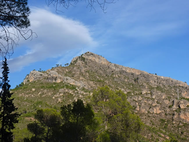
Detour to Risca del Guijarrón
After a slight descent we reach a ravine, and at this point we must leave the track turning to the right along a path, wide at the beginning, on the left slope of Cerro Entredicho.
But before continuing, it is necessary to deviate from the route and follow the track we have traveled from the beginning, to go up to Risca del Guijarrón, 1.4 kilometers away, which is undoubtedly one of the strengths of the stage. Later we will have to return to this point to continue the stage along the aforementioned path.
El Guijarrón, with its 1273 meters of altitude, is a natural balcony that has a spectacular guardhouse, on the cliffs of an aerial rock. From here we can see peaks such as Almorchón, El Banderillas, El Yelmo and Caballo Torraso, among others, and one of the most extensive panoramic views of the El Tranco reservoir. It is quite frequent to surprise elusive mountain goats gracefully avoiding the difficulties of the rocky terrain, and that griffon vultures and the occasional corvid fly over us. From the top we are struck by the Lancha de Guijarrón, a ridge-shaped rock plate that plunges towards the El Tranco dam.
Via Livestock in Los Tres Mojones
The path soon runs above 1,200 meters, leaving behind, on the right, the Cerro del Entredicho and later the Piedra de los Tres Cajones, both above 1,300 meters of altitude. The name of this place responds to the fact that it is the dividing line between three different municipalities, Sorihuela del Guadalimar, Hornos de Segura and Beas de Segura.
Our road travels in this section in a preferably northeast direction until we find the cattle track, where we will turn sharply to the west. In this livestock route, the Bosques del Sur trail coincides with the GR 144 Trashumance trail for just over two kilometers. This section is quite peculiar, because more than a road in the usual sense of the term, it is a wide strip, as is typical of cattle routes. In this case, the livestock route runs through black pine forest with very little scrub, having numerous parallel paths that sometimes intersect. It is the path used annually by thousands of head of cattle in their transit from high mountain pastures to pasture forests with a warmer climate. For this reason, the paths have a lot of loose stone and suffer important erosive processes. There is enough signposting with beacons and rock marks to indicate the correct direction, and at some point there are steps between rock with a certain slope, where you must be careful to avoid slipping.
Fountain Pinilla Track
The cattle track leads to a wide forest track. If we took it to the right, it would take us to the still inhabited farmhouses of Fuente Pinilla, in a small valley that we have previously been able to see from above when we were walking along the cattle track.
On leaving this track we will go to the left, to turn left again after 100 meters along another somewhat narrower forest track. The vegetation in this area is characteristic of the mid-mountain, that is, forests of black pines with romerales and some holm oaks, dotted with cornicabras, junipers and junipers.
Puntal de la Sabina Bifurcation
At this point we must take a forest track, narrow and in poor condition, which comes out to the right heading towards the Arroyo de los Mansegosos valley. But first it is well worth making another small detour of 1100 meters along the track on the left to the Mirador del Puntal de la Sabina, equipped with a panel that interprets the exceptional panoramic views that can be seen, with the places and peaks that can be seen from there toast the walker.
Arroyo Gollete fountain-trough
Going down the left side of the Valley of the Mansegosos, on a curve in the track, we pass a fountain-watering hole on the left, next to some reeds and brambles, which will invite us to make a last stop on the way. On the other side of the valley, a little further down, we can see fruit trees, walnut trees and some poplars, which indicate that the place was once inhabited, since the ruins of the Cortijos de los Mansegosos are located there.
Mountain olive groves
Already in the lower area, with imposing panoramic views of the El Tranco reservoir and its dam, and facing the spectacular Guadalquivir River Valley, we find two small mountain olive groves that we must cross following the track; the first of them has a rudimentary cattle fence and mesh (wire) gates at the entrance and exit. It is very important to close them in our path to avoid damage to the owner, since the fence prevents the entry of deer and other large herbivores to the olive grove. At this point we cross the stream that we have descended through.
About 150 meters before the end of the stage, our track ends in another transversal that we will take to the right, already in front of some farmhouses in the Hoya de los Trevejiles.
Hoya de los Trevejiles Forest House
Finally we arrive at the Hoya de los Trevejiles forest house, where the stage ends. Although it is not restored, the house pleasantly surprises because it is one of the best preserved in the natural park, since it has a fountain, gardens, gazebos, swimming pool and birdhouses, testimony of past times in which the forest heritage managers had reserved some very special places. The forest house is closed and no shelter has been provided there.
Additional information
The black or resin pine
The black pine (Pinus pinaster) is the king of the landscape of this stage, as it is of a large part of the territories of the natural park located in the altitudinal band of 1000 to 1300 meters, and sometimes higher. Its wood is less appreciated than that of the black or salgareño pine of the high areas, but it has a lot of resin, which for centuries has earned it to be highly valued and used in reforestation. In fact, part of the large areas that it dominates today were once occupied by holm oaks, oak groves and lauroid plant formations of strawberry trees, etc.
The resin was extracted through deep cuts to the first layers of the log, channeling the thick liquid that came out to clay containers attached to the trunk, called pots. Turpentine was obtained from it, which had various uses in perfumery and in the chemical industry. In popular medicine it has been used as a balsamic and antiseptic in respiratory conditions.
It is more demanding in heat and more resistant to drought than Salgareño pine, b ...
The black or resin pine
The black pine (Pinus pinaster) is the king of the landscape of this stage, as it is of a large part of the territories of the natural park located in the altitudinal band of 1000 to 1300 meters, and sometimes higher. Its wood is less appreciated than that of the black or salgareño pine of the high areas, but it has a lot of resin, which for centuries has earned it to be highly valued and used in reforestation. In fact, part of the large areas that it dominates today were once occupied by holm oaks, oak groves and lauroid plant formations of strawberry trees, etc.
The resin was extracted through deep cuts to the first layers of the log, channeling the thick liquid that came out to clay containers attached to the trunk, called pots. Turpentine was obtained from it, which had various uses in perfumery and in the chemical industry. In popular medicine it has been used as a balsamic and antiseptic in respiratory conditions.
It is more demanding in heat and more resistant to drought than Salgareño pine, but, compared to Aleppo pine, it requires more rain and supports less high temperatures. That is why it occupies areas of intermediate altitude between both, with which it mixes in the limits of said strip. You need soils with a loose and sandy texture. Compared to the other pines in the natural park, the black crown is especially lush and shiny, and its needles are the longest, stiffest and sharpest. Also its pineapple is the largest, so it is the one traditionally used to light the fire. It can reach 30 meters in height, and the bark is unmistakable: very thick, deeply cracked and with strikingly reddish plates.

Follow us #JaénParaísoInterior


