


Puerto de las Palomas - Arroyo Frío

To carry out this itinerary, the mesta is used, that is to say, a 75 meter wide cattle track; Traditionally, flocks of sheep and cattle mainly cross here, to go from the higher areas of the Park to Sierra Morena, mountains where they enjoy a milder climate in winter.
From Puerto de las Palomas to Arroyo Frio you descend almost 400 meters of altitude in less than 3 kilometers, which gives us an idea of ??how rugged the terrain is.
The Puerto de las Palomas suffered a major fire in 2001 that devastated more than 800 hectares, so the work to recover the area and the road itself have been notorious. Currently the vegetation cover is recovering and many plant species have already colonized the environment.
There are remains of the catastrophe that have been left on the ground to stop erosion, such as logs whose drag would accentuate said erosion and brickwork perpendicular to the slope made with the same burned logs. The steep slopes and the abundance of rocks make it difficult to regenerate the vegetation cover, which is favored by drip irrigation of some species in the summer m ...
To carry out this itinerary, the mesta is used, that is to say, a 75 meter wide cattle track; Traditionally, flocks of sheep and cattle mainly cross here, to go from the higher areas of the Park to Sierra Morena, mountains where they enjoy a milder climate in winter.
From Puerto de las Palomas to Arroyo Frio you descend almost 400 meters of altitude in less than 3 kilometers, which gives us an idea of ??how rugged the terrain is.
The Puerto de las Palomas suffered a major fire in 2001 that devastated more than 800 hectares, so the work to recover the area and the road itself have been notorious. Currently the vegetation cover is recovering and many plant species have already colonized the environment.
There are remains of the catastrophe that have been left on the ground to stop erosion, such as logs whose drag would accentuate said erosion and brickwork perpendicular to the slope made with the same burned logs. The steep slopes and the abundance of rocks make it difficult to regenerate the vegetation cover, which is favored by drip irrigation of some species in the summer months, so we will see PVC deposits and hoses in some places.
The route for the most part is a bridle path, which overcomes the important unevenness through continuous turns, which does not prevent even the horses that accompany the cattle in the transhumance from traveling it. The views of the Guadalquivir Valley, the Poyos de la Mesa, the Banderillas and I include the Yelmo, compensate for the severity of the environment through which we walk, since the green of the great forests that we will contemplate in front of us dominates.
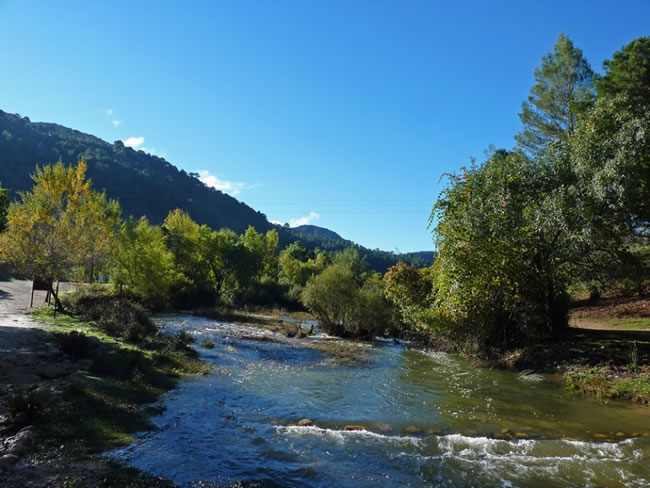
Finally we cross the Guadalquivir in its head section, which in the Natural Park is still a mountain river with crystal clear waters, and immediately we arrive at Arroyo Frío, a village of La Iruela that constitutes the most developed tourist nucleus within the Park, hence the interest of this route to link with the Bosques del Sur Trail.
Technical information
Route Name Rutas Bosques GR247
Rutas Bosques GR247 4: Puerto de las Palomas - Arroyo FríoHUSO 30S
Puerto de las Palomas: x505374 y4200639
Arroyo Frío: x506640 y4199969
Puerto de las Palomas: x505262 y4200431
Arroyo Frío: x506529 y4199762
TOTAL DISTANCE (IN KILOMETERS)2500
Asphalt or cement section 0 %
Section of track or forest road or promenade 26 %
Senda section 74 %
tramos-de-Vía-pecuaria 0 %
ESTIMATED RUN TIMEO
55 minMAXIMUM SLOPE394 m
DIFFICULTY. ASSESSMENT ACCORDING TO METHOD MEASURE
1
MEDIO.
Severity of the natural environment
1
Itinerary
Orientation in the itinerary
2
Displacement
Difficulty moving
1
EFFORT.
Amount of effort required
Rutómetro
Puerto de las Palomas
From the A-319 road, 400 meters from the Paso del Aire, in the Puerto de Las Palomas, we take a forest track, which has several information panels and directional signs.
At the entrance we will find a door that must be closed after our passage, since it prevents the entry of large herbivores (deer, fallow deer, etc.) to the area that suffered the fire through which this path runs.
A few meters away there is a metal passage over a pit that fulfills the same function (Canadian passage).
Track
After the Canadian pass, there is a descending ramp to the right that gives access to a path, which soon begins to wind.
In the first 300 or 400 meters it is advisable to be very attentive to the signs, since the strong erosion of the place can induce us to deviate from the correct route.
Exit to forest track
We come to a forest track that we must take to the left.
If we went to the right, we would walk along the section of the track that runs parallel to the Guadalquivir River to the Cortijos del Coto, very close to the old Valle hydroelectric plant.
Door
Again we find the fence that delimits the area whose vegetation cover is being restored. The track on which we have traveled for a few meters continues in front.
Our route crosses the gate to the right, and again it is important to close the gate when passing to avoid the entry of animals.
From here, already between black or resin pines, the path runs along a track with little use, soon hearing the whisper of the waters of the Guadalquivir.
Cold Stream
Down in the valley, we come across the Guadalquivir River, which we must cross over a bridge on our left.
On the other shore is the end of the route, already in Arroyo Frío.

Follow us #JaénParaísoInterior


