


El Pilarillo - Cumbre de Peñalta

This Bypass, which coincides with the PR-A 180, leads us from the vicinity of the Casa Forestal del Pilarillo to the summit of Peñalta, at 1412 meters of altitude, whose forest guardhouse is perched on a very aerial cliff.
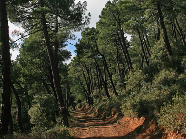
For the most part, it runs through the black pine forest, under which grows a dense undergrowth of holm oaks, kermes oak, juniper, rockrose and aromatic plants such as rosemary, thyme and lavender. In the areas where the rock outcrops, the yellow broom appears.
We will walk along a quiet forest track in a gentle ascent towards the southwest, and then turn towards the northeast with a steeper slope. The last section, already on a bridle path, is done in a rocky and bare environment, but with great views.
At the summit, which is the crown of a sharp ballast, there is a fire guardhouse. From there you can enjoy splendid panoramic views of La Mancha, the Calar del Mundo and the endless alignments of peaks of the Natural Park heading south.
Fox, squirrel and wild boar are very abundant, and it is possible to contemplate mountain goats at the summit. Among the birds of prey, the peregrine falcon, the griffon vulture and the short-toed eagle stand out. In the late afternoon the hooting of the owl can be heard deep in the forest.
Technical information
Route Name Rutas Bosques GR247
Rutas Bosques GR247 1: El Pilarillo - Cumbre de PeñaltaHUSO 30S
El Pilarillo: x533301 y4243371
Cumbre de Peñalta: x531704 y4243651
El Pilarillo: x533190 y4243163
Cumbre de Peñalta: x531593 y4243444
TOTAL DISTANCE (IN KILOMETERS)4785
Asphalt or cement section 0 %
Section of track or forest road or promenade 92,89%
Senda section 7,11%
tramos-de-Vía-pecuaria 0 %
ESTIMATED RUN TIMEO
2 hMAXIMUM SLOPE364 m
DIFFICULTY. ASSESSMENT ACCORDING TO METHOD MEASURE
1
MEDIO.
Severity of the natural environment
1
Itinerary
Orientation in the itinerary
2
Displacement
Difficulty moving
2
EFFORT.
Amount of effort required
Rutómetro
Pilarillo area
The route begins very close to the Casa Forestal del Pilarillo, which has a fountain, although at present it usually has very little water. As soon as we begin, we discard a wide and short path to the left that leads to an old quarry. Our forest track starts quite steeply.
Port of Siles
We reach a hill where we cross Stage 1 of the Bosques del Sur Trail, which here coincides with the GR 147. Our route turns left and climbs, with less slope, through a pine forest of black pine with dense undergrowth, enjoying excellent views in some sections, wider the higher we climb.
Detour to the summit
We come to a hill that is a magnificent balcony to the south of the Natural Park. Here we must leave the forest track to take the path to the right that goes up to the summit, with steep slopes in some sections. If we followed the forest track we would go down towards Benatae, finding a junction with the GR 147.1 after about fifteen minutes, through which we could go down to Orcera via the Hoya de Peñalta and a small traditional signposted path. Going up our way to Peñalta we will see to the left, below, the town of Benatae and, in the distance, that of Torres de Albanchez.
Junction with PR-A 179
We find a junction with the PR-A 179, which is a path that goes off to our left and descends towards the Fuente de San Miguel, in Benatae. We have the option of diverting through this PR and reach, in about 20 minutes, the Buitrera de Benatae, a rocky spur that by itself deserves a visit for its views of the forests and creeks in the north of the Park. Our route continues along the main road. We can rest in the impressive natural viewpoint that we have on our right. At kilometer 4.6, the path turns into a beautiful path, on bare terrain and with great views.
Peñalta Summit
We arrived at the forest guardhouse on the summit, perched on a very aerial cliff. The panoramas are extraordinary in all directions. To the north we see Benatae, Siles, Piedra del Cambrón and Almenaras peak, already in the Sierra de Alcaraz, the views widening by the immensity of the plains of La Mancha. To the south stands out the mass of El Yelmo, Segura de Sierra crowned by its castle and, in the background, the waters of the Tranco reservoir and the Sierras de Cazorla and Las Villas. And to the east, we contemplate the great Segureño creeks of Navalperal, El Espino and Cobos.

Follow us #JaénParaísoInterior


